Photographies: Santiago Navarro y Aldo Santiago
In the northern lands of Petén, Guatemala, a project is being developed by a group of international NGOs, together with their local partners and the financial support of institutions like the United States Agency for International Development (USAID). These NGOs include The Nature Conservancy, Wildlife Conservation Society, Rainforest Alliance and World Wildlife Fund. Using a discourse of combating global warming and protecting forests, this project aims to profit from the indiscriminate sale of forests.
The creation of the Maya Biosphere Reserve in 1990 (RBM, by its Spanish acronym) generated the conditions to insert this territory—which covers 70 percent of Petén department—into national “sustainable development” plans. These plans are based on the exportation of commodities alongside conservation projects, and they exacerbate the seemingly contradictory nature of these initiatives: The Mesoamerica Plan for infrastructure and economic-energy integration with its extractive projects; and its “green version”, the Protected Areas of the Mesoamerican Biological Corridor. Both of these land management models are financed by the World Bank and the Inter-American Development Bank (IDB).
These models, which advertise “sustainable forest management” projects within the Reserve as conservation success stories, seek to shape the Guatemalan regulatory framework to include a new commodity for export: carbon credits. These credits come from so-called offset projects—in which contamination or destruction of one place is offset with a project in another place that claims to protect a “similar” area, or “recreate” what has been destroyed. This not only allows all industrial activity to continue—as long as its destruction is “offset”; it also causes double land grabbing: in the area of the industrial activity and in the “offset” area.
In a context of growing militarization in northern Guatemala, these plans intend to continue the forced displacement of peasant and indigenous populations who have been living in Petén for decades.
Living Under Threat
"My family began to form this small community", says Ignacio while stubby arms of his young son frolic with his face. The shadow of his house, a precarious palm hut, gives us the space to rest after the tour through the dense forest guarded by the inhabitants of Nueva Jerusalén II, a town located within the territory demarcated as Sierra Lacandón National Park (PNSL), department of the Petén in the north of Guatemala.
“They came out of necessity, and with the hope of getting a piece of land; and we have worked the land in an organized fashion”, says Ignacio, continuing his story while his son rests in his arms. “When it is time to do agricultural burning, we organize into groups and by date and time. We know that nature is important and that we can't destroy it, because we're thinking about the lives of these children”, Ignacio says. He also says it is complicated to live in his community, due to the rough roads that lead to it.
Traveling to Nueva Jerusalen II is treacherous. The Avispa Midia team accompanied a group of peasants making their way through a gap where dirt roads and mud mix—a spot that is impassable during the rainy season. Community members make the trip in groups, which enables them to go down to, and return from nearby towns where they get basic supplies that are not sent to their community. Vehicles commonly get stuck in the thick layer of mud along the path uphill toward the mountain, and are not able to climb further. This includes even four-wheel drive trucks, such as the one used on the occasion with Avispa Midia.
“It has been disturbing to us to see how powerful business sectors have been destroying nature in what they call Protected Areas”
Laguna del Tigre
“Basic services are restricted in all PAs: health, education, food, infrastructure”, says Roberto, who lives within the area demarcated as Laguna del Tigre National Park (PNLT, by its Spanish acronym), which is also within the Maya Biosphere Reserve (RBM). Along with a group of community members from the most diverse villages within the RBM, this young man participates in a training course for community health promoters in El Naranjo, the urban center on the edge of the San Pedro river in the municipality of La Libertad.
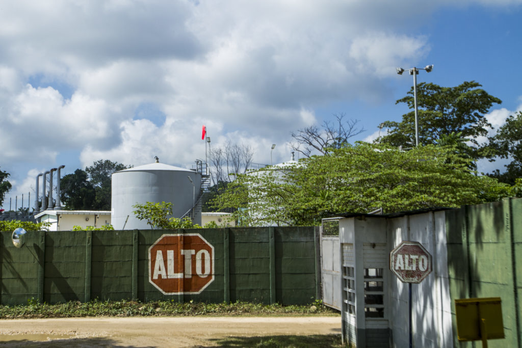
In the case of the PNLT, the Guatemalan government signed an agreement with the British-French oil extraction company, Perenco, wherein the company has committed to providing health services for the residents located in the vicinity of its facilities. “They use very strong, bad-smelling chemicals here; they use acids that spread throughout the area and are carried by the wind. In communities like ours that live nearby, most people suffer from intense headaches caused by [these chemicals]. The company's health services are a total sham; it hasn't even provided first aid kits or equipment in the communities. And in some cases the nearest health clinic is 180 kilometers away!” Robert and his classmates report.
“Health is a critical issue in the PAs. It is pretty painful; people die and nobody says anything”, says Robert, who—like the others present—is the only medical care provider in communities where there is no infrastructure, let alone healthcare workers.
Not only are Perenco's activities reduced to a monthly visit with insufficient medicine; the problem is worse in communities near oil wells, due to the contamination. The youth report that “there are diseases that occur only in those areas—such as allergies and throat and ear problems—for which medicine is not available”.
“It has been disturbing to us to see how powerful business sectors have been destroying nature in what they call Protected Areas. After we have been robbed of our lands, they end up in the hands of other people; and legally, they can belong to a company. We are angry that they hassle us about so many things; yet we see the oil bids in Laguna del Tigre, where there is also (oil) palm....Why do they have the right to be here? If they actually are contaminating nature!” ask the health training participants.
“We are living in a critical situation, because we don't have any basic services. We are totally abandoned”, shares Ignacio, a peasant from a community criminalized by the National Council of Protected Areas (CONAP, by its Spanish acronym) and conservation NGOs. These institutions use discourse that blames community members for the destruction of the second largest forested area in Latin America.
“It is impossible to live in this situation” decries Ignacio, who—like 60,000 peasants from communities located in the PNLT and PNSL—lives under the threat of being forcibly displaced from his land. Despite having lived in the area for over three decades, well before the RBM was created, they are accused of being “invaders” by CONAP. This institution at one time drew the lines to demarcate these communities through its Monitoring and Evaluation Center.
“They forbid us from building houses. Buying materials and bringing them in is forbidden. Yet they also arrest us if they catch us cutting a palm tree”, Ignacio says. He denounces the fragility of his residence in the Protected Area, and expresses his lack of knowledge about the refined mechanism through which he is being criminalized: the lucrative carbon markets that covet their lands, and the financial strategy that aims to strip community members of their territories—under the pretext of environmental “conservation”.
Displacement: State Policy
On Friday, June 2, 2017, 111 peasant and Mayan Q’eqchi’, Ch’orti, Mam, Achí, Kaqchikel and Xinca families fled their lands in the face of the threat of 2,000 troops from the army and the National Civil Police (PNC, by its Spanish acronym). The troops were headed toward their community—known until then as Laguna Larga—with the sole objective of reducing it to ashes. To this day, 450 forcibly displaced people are living in a humanitarian crisis context on the border between Campeche, Mexico and Petén Guatemala.
The case of Laguna Larga and other forced displacements that have occurred in the PAs show how the Guatemalan State uses violence as a way to resolve territorial conflicts in Petén. Moreover, global discourse on combating climate change reinforces local policies that aim to destroy communities, by labeling them as “illegal”,—all the while ignoring the main causes of forest devastation: oil extraction, organized crime activities, and more recently, the expansion of agribusiness plantations.
The main objective is to prohibit the presence of communities that do not adopt the only model allowed in northern Guatemala: that of the forest merchants.
The Path Toward Conservation
In the far north of Guatemala, on the border of Mexico and Belize, Petén department gained greater relevance to the State with the discovery of oil reserves in the 1960s. The National Enterprise for the Economic Development of Petén (FYDEP, by its Spanish acronym) was created to stimulate the colonization process—and in part to counterbalance Mexico's hydroelectric plant construction projects on the Usumacinta river. This institution completed construction of the first highway connecting the state capital to Guatemala City.
Meanwhile, inequality in the distribution of land and wealth, as well as interference by the US and US-based companies, framed the development of the internal armed conflict in the rest of the country. This led to an exodus toward Petén that lasted for decades. By 1980, the number of land applications from peasants to the FYDEP (which was being funded by USAID in a counter-insurgency context), reached 50,000. However, strict military control over the institution favored the army and landowners on the southern coast, granting them large tracts of land.
Thus, in the second half of the 20th century, the industries that had collected rubber were converted to huge territories used for cattle ranching, monocultures for export, and oil extraction. The Master Plan of the PNLT has identified the latter activity as the main driver of territorial devastation, due to the opening up of roads. 90% of the deforestation in the park has occurred fewer than 2 km away from the roads that the oil company built. Additionally, the drilling of dozens of wells, and spills from pipelines, contaminate the water, air and soil—causing diseases in communities.
These organizations' concept of conservation can be seen as part of the neoliberal model, given the way in which Protected Areas are viewed economically. If the State wants to conserve, it has to pay to do so.
In 1986 FYDEP disappeared. Three years later, the Law of Protected Areas came into effect, and in this framework the RBM was created. The RBM comprises 2.1 million hectares, including what are known today as the PNSL and PNLT. These national parks house rural communities that have been settled there since 1960, and have sustained themselves by growing crops for their own consumption.

“They eliminated the FYDEP in an institutional reengineering process in Guatemala that was promoted by World Bank models. In this transformation, they changed the Petén forest reserve to a Protected Area”, says Rosa María Chan Guzmán, a former cultural and natural heritage official for Guatemala, who is convinced that forest conservation only happens if there is money in it.
Environmentalists and environmental organizations promoted this model before the negotiations and signing of the Peace Accords, which targeted Petén in the demand to allocate lands to hundreds of peasant and indigenous communities displaced throughout Guatemala. In so doing, promoters of the creation of institutions like CONAP discarded the idea of consulting communities already settled in Petén. Meanwhile, the creation of Protected Areas served as an excuse to maintain and expand military presence in Petén, in the name of protecting and defending the environmental heritage.
Meanwhile, since their inception, official institutions tasked with enforcing the Law of Protected Areas have operated on limited budgets. This has led to the proliferation of conservation NGOs to fill the institutional gap.
“These organizations' concept of conservation can be seen as part of the neoliberal model, given the way in which Protected Areas are viewed economically. If the State wants to conserve, it has to pay to do so. The State was clearly not going to have the technical capacity to manage these areas; they were always intended to be transferred to conservation NGOs. One of the first to be created, the Foundation for Eco-development and Conservation (Fundaeco, by its Spanish acronym), is owned by Marcos Cerezo. Marcos Cerezo is the son of Vinicio Cerezo, who was the president of Guatemala when the Law of Protected Areas was passed. This NGO manages geologically strategic areas, where there is gas and oil”,
SAYS ROCÍO GARCÍA, AN ANTHROPOLOGIST FROM THE UNIVERSITY OF SAN CARLOS. SHE DENOUNCES THE IRREGULAR WAY IN WHICH THE MANAGEMENT OF PROTECTED AREAS WAS TRANSFERRED TO PRIVATE INVESTORS, WHO THEREWITH HAVE THE ABILITY TO ADMINISTER STATE RESOURCES IN THE FUTURE.
Free-Market Environmentalism in Petén
“The reconfiguration of capital has an effect on territorial reorganization. Most recently, we saw this with oil palm, but we did not realize that it began early on with the PAs”, stresses the anthropologist García, for whom the creation of the Guatemalan System of Protected Areas, Decree 4-89, is the tip of the iceberg of territorial reorganization in Petén.
The government declared the first Protected Areas in 1956; however, it was after the Law of Protected Areas passed in 1989 that a surge in the creation of similar areas took place. From 1996 to 2009 alone, 120 areas were declared. The system currently has 339 conservation areas covering over 3 million hectares—about 32% of the national territory.
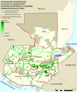
The Law of Protected Areas, inspired by conservation models imposed by international agreements, quantifies what can be done on a piece of territory, who can enter, and under what conditions. As such, the model is integrated into the Mesoamerican Biological Corridor proposal (CBM, by its Spanish acronym). Planned since 1992, the CBM has an approximate price tag of $US 470 million, and involves developing national and regional projects in adjacent Protected Areas, on 768,000 km2 of land that contains 10% of the world's biodiversity.
According to Rocío, author of the thesis, “Kaxlan Territory-Q’eqchi’ Territory: Conflict in Protected Areas of Livingston, Izabal”, there are four strategic business aspects to the PAs: a) as a catalyst and guarantor of income from the land; b) as an opening to the market for environmental goods and services; c) as a natural resources reserve for industry and future markets; and d) as an investment in the “symbolic” field, wherein they can capitalize on building an image of corporate responsibility.
Thus, conservation of the Mesoamerican Biological Corridor is approached as a business. In addition to producing carbon credits from “sustainable development” activities, this conservation establishes land use planning in Mesoamerica based on the environmental goods and services that it wants to extract and protect at the same time.
Ranching Yesterday...What Today?
The road that leads from El Naranjo to the border with Tabasco, Mexico—and which passes through the municipality of San Andrés—is lined with pastures directly in the RBM Buffer Zone. For kilometers, workers and cattle intermingle on farms, many of which comprise several hectares of land and have huge constructions on them.
The route—along which several rural communities are settled, and which is used for migration—is interrupted by up to three military checkpoints. The presence of these checkpoints has intensified abuses against pedestrians since implementation of the Special Jungle Operations Brigade. Funding for the Brigade is part of an extended contract to Perenco, and its main detachment is adjacent to the Xan oil well.
Along the road, one can see the forest degradation caused by ranching, which has destroyed 8% of the RBM since 2000. Part of this expansion has been driven by “narco-ranchers”, who use the profits from criminal activities to invest in huge amounts of cattle—and even oil palm plantations—as a strategy to launder money from illegal activities.
But the development of ranching as a major activity in Petén is not new. It began with the administration in office after the coup d'état of 1954. “From that year onward, the United States government had a strong political and economic influence on Guatemala”, recounts Luis Solano, political analyst and author of Guatemala: petróleo y minería en las entrañas del poder. He underscores the importance of the alliance between Guatemalan politicians and military personnel and US officials—an alliance which allowed them to take over large tracts of land. Solano provides context on agricultural land management in northern Guatemala during the war: “During the counter-revolutionary period, they created parcels of land in response to the interrupted land reform process. Settlers were granted parcels of land, initially in the municipality of Ixcan and later in all of Petén. Over time, many communities chose other forms of organization, such as cooperatives, but later had to leave their territories due to the internal armed conflict”.
After the coup d'état, government policies were created and dictated from the north. One of these policies promoted cattle ranching for export to the United States. Due to its official promotion, ranching destroyed large areas of the rainforest in Petén. This in turn led to the reconversion of territories to other legal and illegal industries—given that pastures are sometimes used as a land use pattern until profitable markets emerge.
“When PAs are installed the intention is to recover the area, however the reality of ranching is already in place. Many people depend on it; ranching is the biggest business for communities, and in legal terms as well”, Solano says. He believes that government and NGO accusations that peasants are complicit in illegal activities are unfounded.
“In the last 50 years, Petén has gone from being an inhospitable area to a region with organized crime, where the Guatemalan State is a participant. It is well documented by the press that the army is really controlling drug trafficking in the country; because criminal organizations would not be able to operate without its support”, says the researcher.
According to a census by CONAP itself, up to 84% of park inhabitants are farmers or day laborers who make a living growing corn, beans and pepitoria (a kind of squash). Between 15% and 24% are ranchers, although most of them have few animals. Large-scale cattle ranchers, those capable of enclosing farms of thousands of hectares, do not live within the Protected Areas. Who is Destroying?
The RBM is one of 610 “Biosphere Reserves” designated by the United Nations Educational, Scientific and Cultural Organization (UNESCO). According to UNESCO regulations, this allows for “productive activities with the stipulation that there be a balance among development, conservation, and the adaptive management of areas”. However, as in several Biosphere Reserves in the world, oil activities with high environmental impact also take place in the RBM in Guatemala. These include drilling dozens of wells, refining crude oil in “La Libertad” and laying more than 120 km of oil pipelines.
While the contract to exploit the “Xan” oil field in Laguna del Tigre National Park (PNLT) was, indeed, granted before the region was declared a PA, when the first 25-year concession expired in 2010, an unusual 15-year extension to the contract was signed. This was despite evidence that Perenco's operations in Laguna del Tigre are causing contamination and deforestation, and threatening the most important freshwater wetland system in Central America.
In 2012, former CONAP official Sergio Enrique Véliz Rizzo was sentenced to three years in prison for his role in modifying the 2007-2011 PNLT Master Plan in such a way that it facilitated extractive activity. This modification mutilated the parts that discussed the negative impacts of oil activity in the PNLT, and eliminated the clauses prohibiting the establishment of new oil exploitation within the park.
But the green light for the oil company came from higher up. Despite the obvious illegality of its presence within the PNLT, Perenco obtained the extension on the oil contract due to a direct decision from former president, Álvaro Colom. Colom is currently in pre-trial detention for charges of fraud and corruption during his tenure.
On the edge of the PNLT, within the buffer zone, the Ocultum project is also in operation. The operating company, City Petén, has a contract to explore 39,555 hectares. In the same region, the areas collectively named Cotzal have also been granted to Perenco. The river and lake water systems would be most affected in the event of an oil spill in this area.
The greatest potential risk comes from the pipeline's passage through the San Pedro River, which—in the event of an oil spill—could have catastrophic impacts on the biosphere and human communities. This is especially true given that two sites of special interest are found on this river: mangroves and freshwater coral reefs where mollusks live.
Despite the fact that one of the strategic objectives of the RBM Master Plan was to cease oil exploration and drilling in the PNLT by 2016, this goal is far from being reached due to industry interests. In 2017, the country's oil industry produced 3.5 million barrels, and of that total, Perenco in Petén produced 83.5%.
Other current processes have also come into conflict with communities and RBM-demarcated areas. Such is the case of the expansion of oil palm cultivation. “There was a biological reserve in Sayaxché called the San Ramón farm. Since the 1990s its area has been reduced, and today, its entire perimeter is planted with oil palm. All of those plantations belong to the five largest landowning families in the country”, Luis says. He identifies this as the reason for the total impunity enjoyed by those involved in the appropriation of large tracts of land demarcated as Protected Areas.
“There are signs of oil palm cultivation on the edge of the Sierra Lacandón; as well as south of Petexbatún Lake—where the lands were previously converted from forest to ranching pastures. They burn the forest, and suddenly you see palm trees in the PA II complex, south of Sayaxhé city”,
SAYS ROSA MARÍA.
Community members in the PNLT say they are concerned about the expansion of oil palm plantations in the RBM. Currently, there are signs pointing to the presence of palm plantations in the Buffer Zone, but there is a real concern that they could expand illegally into other areas of the Reserve. If this were to take place, it could have potentially devastating impacts on waterways and wildlife—such as the impacts resulting from the ecocide of the La Pasión river basin in 2015.
“There is already palm in Laguna del Tigre. There are landowners with up to 4,500 hectares who have long-term plans to install plantations near the border between Guatemala and Chiapas”, said peasants from the area who were interviewed anonymously.

Other reports attribute the expansion of the industry to the alliance between drug trafficking and oil palm, as in the case of the La Pujuquera farm. This farm belongs to Oswaldo Bolaños, who was prosecuted in the Unites States for drug trafficking and money laundering. (He was released, however, in 2015.) Testimonies from the area say that palm plantation operations dump chemical waste directly into the Sacluc river, within the PNLT.
“Community members are demanding eviction of the narco-farms, and an end to the menace of large tracts of land being granted to agribusiness for oil palm, teak and melina plantations (timber trees for export)”, affirms Solano. He criticizes the Guatemalan State's inaction of not standing up to those who are truly responsible for the movement of drugs in the region.
“I was in the Sierra Lacandón National Park between 2001 and 2004, and there were signs of drug trafficking”, reports Laura Hurtado, director of Action Aid Guatemala. “All the evidence was there, and the State did nothing. Even the gringos didn't do anything, because there was USAID funding in the region; so they didn't get involved in the issue. Worst of all, there are communities in the same area who are restrained by the Law of Protected Areas, but with rights that were in place prior to the creation of the area. They are facing the threat of likely eviction”, says the researcher regretfully. Despite the fact that the US agency invested over US $40 million over more than a decade, illegal activities—far from ceasing—continue throughout Petén.